

Hurricane Idalia — What Happened To Cotton In the Southeast?
⋅ BY CARROLL SMITH ⋅
EDITOR
At the end of August, Hurricane Idalia entered the Gulf of Mexico and slammed into Florida’s Big Bend region as a Category 3 storm. Cotton farmers in the Southeast kept a close eye on the forecast to try to determine where it would go from there. It was soon obvious that the path included coastal Georgia before heading into South Carolina and eventually North Carolina.
Georgia cotton specialist Camp Hand said the most affected areas in his state were Lowndes and Brooks counties. From there, it tracked northeast through Cook, Berrien, Clinch and Lanier counties, over to Appling County and then into Bulloch County and the Statesboro area.
“Idalia hit a good bit of Georgia but, fortunately, by the time it got out of Brooks, Lowndes, Lanier and Clinch counties, it was mostly rain,” he said. “We had a good bit of wind in spots that blew the cotton around, and there were some fields where the cotton plants were on the ground. Statesboro got about 10 inches of rain, and other areas reported 4 to 6 inches.”
Hand said the cotton was in various stages at the time. Some fields were close to defoliating, and others had not even started opening.
How The Carolinas Fared
Idalia’s next stop was South Carolina where cotton consultant and farmer, Drake Perrow, is located in Calhoun County. He said they had a good bit of 45-mph-wind, which was enough to tangle up the cotton and make it impossible to see the rows. But the rain was probably the most notable aspect of the storm.
“In a 20-mile radius from where I am, the rainfall was anywhere from 3 inches to 13 inches,” Perrow said. “I had 6 inches here at my house. The cotton was just starting to open in the bottom, and we had started dropping some leaves so the air was circulating. The sun was out the next morning, and I noticed very little boll rot afterwards. The worst thing I saw was the tangled cotton, which means you can’t go through the crop with ground equipment anymore. However, we were at the last stink bug and Pix applications, so if we had to have a storm, this was probably the best timing for it.”
North Carolina cotton specialist Guy Collins said, “Normally, we cringe when we hear the word hurricane, but when Idalia came through, our cotton was closed, and we were real dry. This storm that brought rain was more of a blessing than anything.”
Collins said the crop ended up being kind of early because of the drought stress, but as of mid-September, it was not ready to harvest yet.
“My wife will tell you that after Labor Day my blood pressure goes through the roof,” he said. “Too many times I’ve seen a real good crop go completely south because of a hurricane. And sometimes it’s not just a hurricane. September can be cloudy and wet, so the crop doesn’t dry out. Then we are set up to have hard lock issues and maybe some boll rot — another way of losing the crop. I’m just uneasy at that time.”
Tracking A Storm
When there are reports of a hurricane or tropical storm potentially threatening the Southeast, Hand said his first reaction is to tighten up while thinking, “Oh, no, there’s another one heading this way.” Then he starts watching the forecast. Two of his favorite resources to follow are James Spann — a meteorologist with ABC 33/40 in Birmingham, Alabama — and climatologist Pam Knox with University of Georgia Extension who runs the UGA weather monitoring network.
“If a storm is getting close, James provides updates three times a day,” Hand says. “I keep my eye on that. Pam also provides extremely well-timed updates on storms, tracking and potential impacts. She stays in contact with Extension specialists and county Extension agents. I pay attention to what local people are saying and follow the National Weather Service. I put a lot of time into tracking a storm — where it’s headed, how strong it’s going to be and the amount of wind and rain to expect. I start having conversations pretty early with Taylor Sills, the executive director of the Georgia Cotton Commission, in terms of what we need to be getting ready for.”
Hand says as soon as the storm passes through, he hits the road to check fields to see how bad the damage is. Over the next few days, he reaches out to county Extension agents to tell them what he has seen and ask what they have seen, so they all can work together on a path forward.
Collins said when he sees a storm developing, he watches it like a hawk. If one looks like it can potentially hit, he advises growers not to defoliate if they have closed bolls. If the storm is about a week away, and some of the cotton has already been defoliated, he recommends harvesting it the best you can and get it out of the field or at least in a module.
“The problem is we don’t always have a lot of notice as to whether a storm is coming here,” Collins said. “We may know if it’s going to get close, but getting close is essentially no impact, but a direct hit is a major impact. If we could have more precise notice, we’d be better off in terms of making decisions.”
Defoliation Decisions
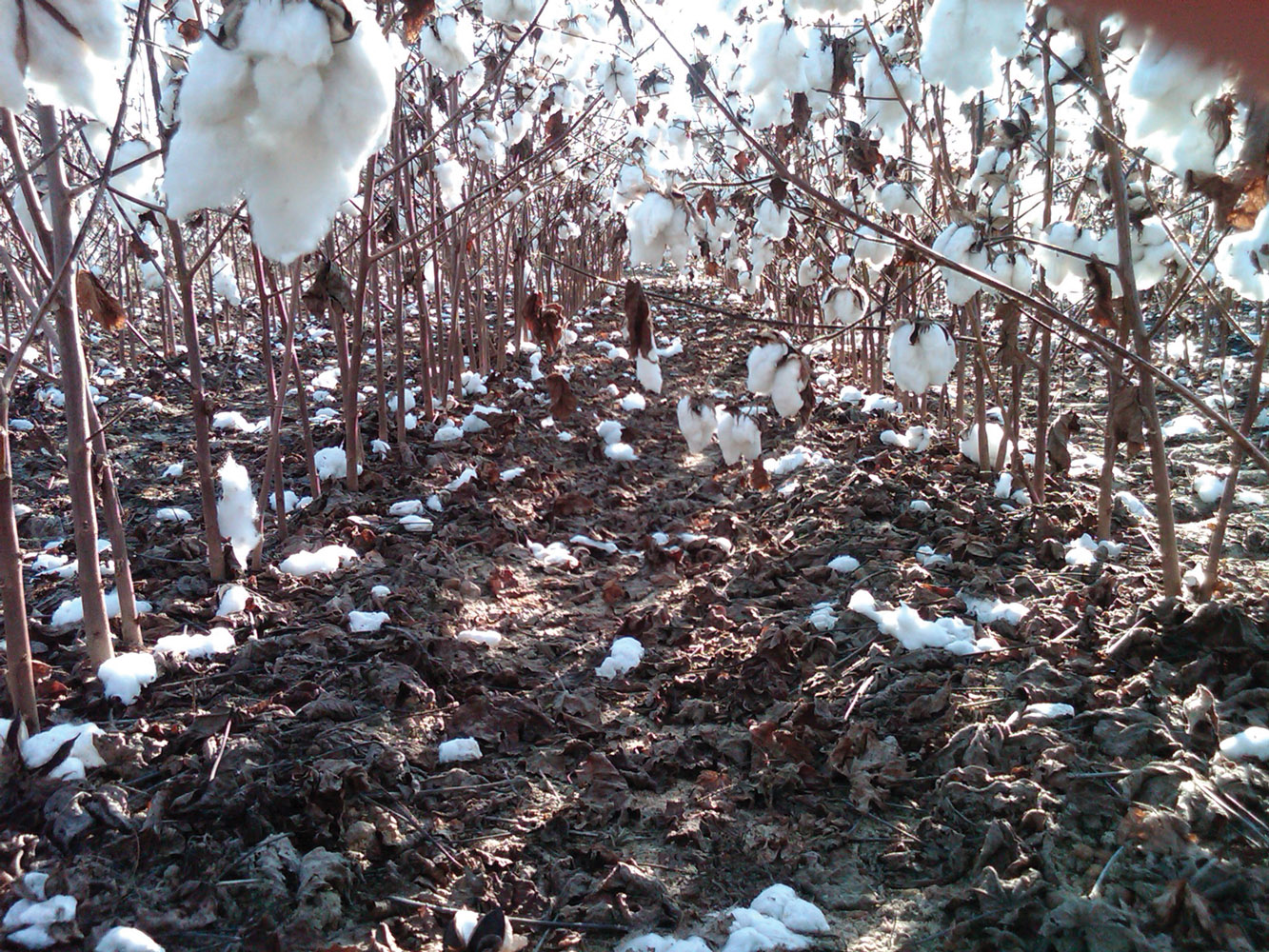
“When I see a storm coming, I am not going to defoliate,” Perrow said. “I want all the leaves on there to protect the cotton a little bit. I remember when Hurricane Hugo hit, we had just defoliated a lot of the crop. Afterwards, cotton was everywhere. The ground looked like snow.
“A good many people take out hurricane insurance now. That helps. There are a couple different qualifications to collect, such as sustained winds at a sustained speed for a certain amount of time. The amount of rainfall is also considered. One good point about this insurance is that if one county meets these qualifications, then an adjoining county can benefit from it, too.”
To gather data that will back up North Carolina’s recommendations to farmers about waiting until the storm passes before defoliating, Collins is working on a simulated study about what can happen with various degrees of wind.
“Most growers are concerned they are going to get behind schedule if they don’t go ahead and defoliate,” he said. “But there is not much point in being on time if there is nothing to harvest. We want to protect the crop as much as we can, so we are creating hurricane force winds and trying to quantify what the losses would be for both a stormproof variety and one that’s looser in the burr.
“The study is being conducted with leaf blowers and a pressure washer. I underestimated how much work it would be and that we would be out there getting wet! Sometimes we try to get creative in our research, and this is one of them. 2023 is an experimental year to see if we can make it work and how well we can make it work. It’s quite an undertaking.”