

Why Hurricane Insurance Is Not Paying For Many Farmers’ Claims
⋅ BY PAM KNOX ⋅
UNIVERSITY OF GEORGIA
I have received many questions about weather-related crop insurance and why the counties designated by the Risk Management Agency do not match what they have experienced in their area. Producers are frustrated when they experience weather that they think clearly meets the requirements for the insurance, and yet they are not considered as affected counties by the RMA.
My goal in this article is to explain the wording of the crop insurance and what datasets are used to determine whether a county is eligible for an insurance payment. I am not here to blame RMA, National Oceanic and Atmospheric Administration or any other group for the determinations.
I will just tell you about the insurance wording and the datasets and what they do and do not show. Everyone wants to make sure the appropriate producers are getting paid in the quickest way possible. But the way the insurance policy is written limits who will get payments. The wording of the RMA insurance policy can be found at the RMA website at rb.gy/91xh7f.
A Named Storm
Weather Event refers to a named tropical cyclone, as identified by NOAA and determined by Federal Crop Insurance Corporation in accordance with the Hurricane Destruction Potential and identified in the actuarial documents, which includes hurricanes and tropical storms.

To meet the County Loss Trigger:
■ A hurricane must have maximum sustained surface winds of 64 knots (74 mph) or greater in a county or adjacent county.
■ A tropical storm must have: (1) Maximum sustained surface winds ranging from 39-73 mph (34 to 63 knots); and (2) A Final Rainfall Amount of at least 6 inches received over the following four consecutive days: (i) The day immediately preceding the arrival date of the tropical storm; (ii) The arrival date of the tropical storm; and (iii) The two days immediately following the arrival date of the tropical storm.
The key points here are that it needs to be a named storm, it must have had observed sustained winds of a minimum value that depends on whether it is classified as a hurricane or tropical storm. In the case of the tropical storm payment, it must have had measured rainfall measurements of at least 6 inches over a four-day period.
Note that sustained winds are generally considered to be an average over a period of time, like a one-minute average. Gusts are not used because they are instantaneous measures of the wind speed over one second. Those winds are measured at 10 meters (33 feet) above the ground.
Note that not just any weather data can be used to make the determination. According to the RMA Frequently Asked Questions, NOAA IBTrACS data is used to determine wind extents for Hurricane and Tropical Storm county loss triggers. [The International Best Track Archive for Climate Stewardship (IBTrACS) project is the most complete global collection of tropical cyclones].
In addition, NOAA-Climate Prediction Center data is used to determine the Final Rainfall amount for Tropical Storm county loss triggers. The rainfall observations are put into a model that interpolates the values to a grid.
The county rainfall is calculated using an area-weighted total rainfall for all grids that intersect that county. The rainfall average for the entire county must be greater than or equal to 6 inches, even if some stations are greater than that and others are below that threshold. You can read a detailed description of the rainfall dataset at CPC_Gauge_Ananalysis_Procedure_final_20210316.pdf.
NOAA-CPC only uses weather stations certified by the National Weather Service Office of Observation as having a long and reliable record and available through the official NWS data stream. They specifically say that CoCoRaHS (Community Collaborative Rain, Hail & Snow) data are not included in this list for rainfall.
Tropical Storm Debby
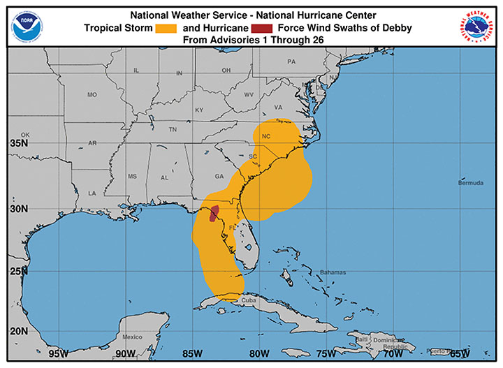
This year I received a number of requests about eligibility for tropical storm payments from Tropical Storm Debby after it occurred in early August. In most cases, the counties that did not receive primary status did not receive it due to the rainfall limit, not the wind limit.
Even though there were many observations in a county that met the 6-inch requirement, there were not enough official gauges that measured over 6 inches to affect the county-wide average based on gridded data. The map shows roughly where the tropical wind speed requirements were met from Debby.
In most cases, once Hurricane Helene moved over Georgia, the hurricane insurance coverage overwrote the tropical storm coverage from Debby, although that was not true in all cases, especially in eastern Georgia.
Hurricane Helene
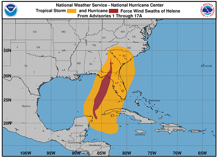
For Helene, most of the questions focus on the dataset called IBTrACS and how is it determined. Based on my conversation with Deke Arndt at the National Centers for Environmental Information, RMA uses the hurricane track information from the National Hurricane Center.
This includes the center position of the storm and the radii of winds in the four quadrants, which is essentially the same thing as the IBTrACS database. The initial estimated NHC wind map from Helene is shown.
Note that this does not include a lot of wind observations to the right of the track because most of those NWS Automated Station Observing Systems were offline due to power outages and were not included in the original IBTrACS database.
I think it is also important to note that National Centers for Environmental Information is located in Asheville, North Carolina, and was without power, water and internet for a significant amount of time after Helene moved through, which undoubtedly affected their ability to gather the data as quickly as RMA needed.
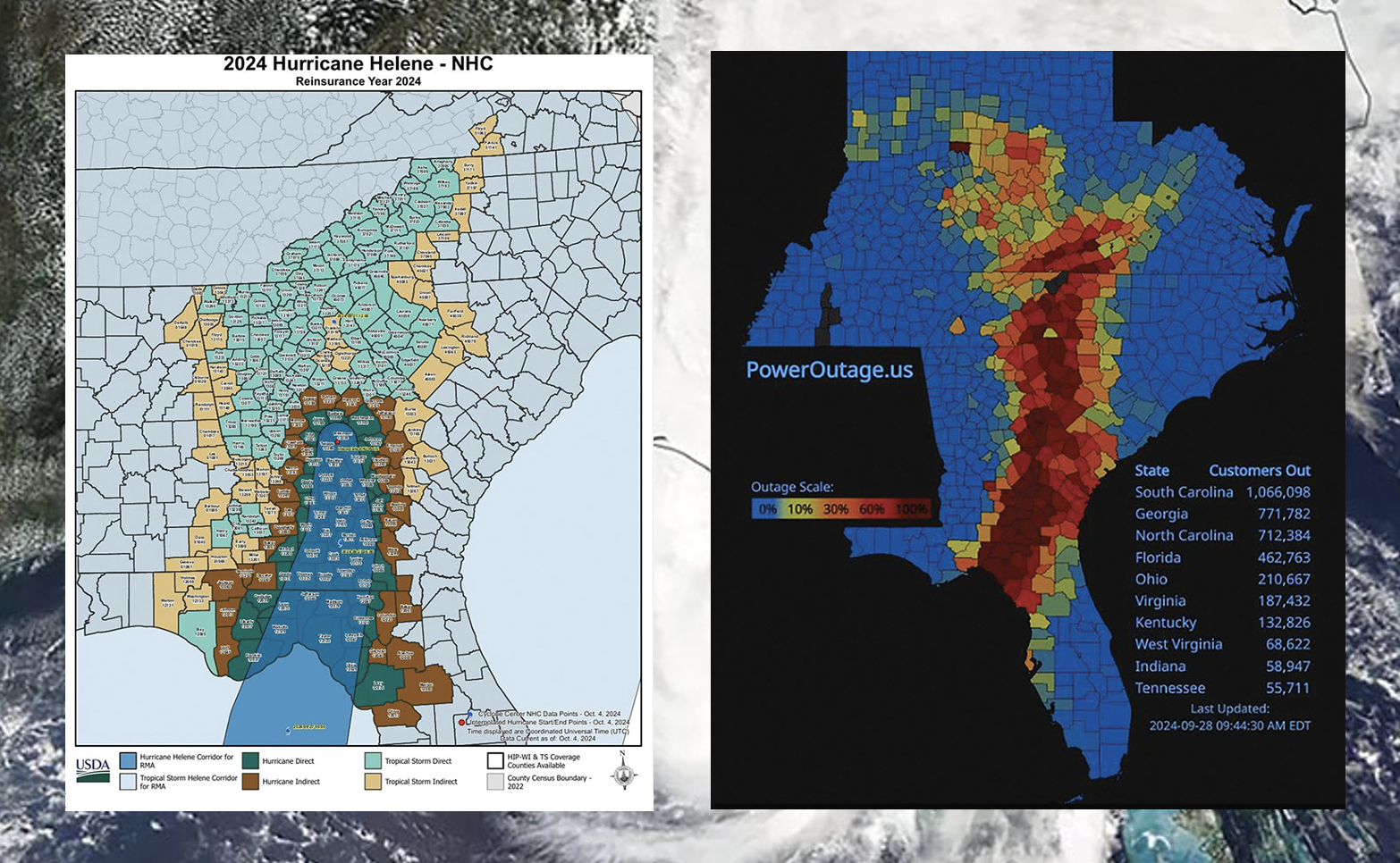
If you compare the payout map to the NHC hurricane track, you can see the counties identified as Hurricane Direct counties for Helene are mostly along the original path of the hurricane as estimated by NHC.
However, the strongest winds in Helene as measured by damage were much more widespread to the east of the track than is shown in the NHC depiction of where hurricane winds occurred. The power outage map shows where the worst damage occurred.
According to the damage track, there was widespread damage from Helene from the eye of the storm all the way to the Georgia coast, although it is impossible to determine what the exact wind speeds there were because most official observing sites were not operating due to power losses.
Wind over land is often more turbulent than over the ocean, and topography like hills and valleys can cause big differences in wind speed. There could have been pockets of wind that were sustained at more than hurricane-force in some places. But with no observations to verify that, there is no way to use that information to collect insurance payments because they are not official observations.
We also need to keep in mind that when the ground is saturated, trees are more likely to fall over in high winds. The damage, including power outages, may be worse than if the wind occurred with less rain.
The Bottom Line
These statements are my own opinions:
• I understand why they used the IBTrACS database to get wind observations. It is quick and allows fast relief to farmers who are in the designated areas without having to wait weeks for official weather data. Wind measurements are messy and often affected by the location of the instrument. But it does not work well when the actual wind field of the hurricane does not match the estimated circular field identified by NHC at the time the hurricane moved over land.
It does not account for things like interactions with topography, local circulations within convective bands, tornadoes or other small-scale circulations within the larger hurricane or interactions with fronts that may increase winds in some places far from the eye of the storm. It may also not account for loss of data due to power to the NOAA stations, although they may have corrected for this.
The UGA Weather Network has provided all of our wind data to a group that is producing an enhanced wind field for FEMA. But, I don’t know if this will be used at a later date to update the RMA map of direct and indirect counties or if it is being used for something completely different.
■ I understand why they use counties as the designated entities for determining if producers are eligible for insurance payments since many government agencies are set to work on a county basis.
However, it hurts farmers in large counties where there is a high variation in weather across the county because of where the path of the storm is, especially for rainfall.
In that case, nearly half the county’s producers could not get a payment because the average rainfall for the entire county is less than the required 6 inches, even if the wind criteria were met.
■ I think Georgia is particularly hurt by the reliance on county estimates, since we have more and smaller counties than surrounding states. This means our swaths of direct and indirect counties are often narrower than in states with bigger counties.
I hope that this lengthy explanation will provide some insight into how RMA hurricane insurance payments are made, even if it gives you no satisfaction that all the producers who need help will get it from insurance. I know you are all worried about them (and in some cases may need Hurricane Insurance Protection-Wind Index (HIP-WI) insurance yourself for your own farms) and want what is best for them.